
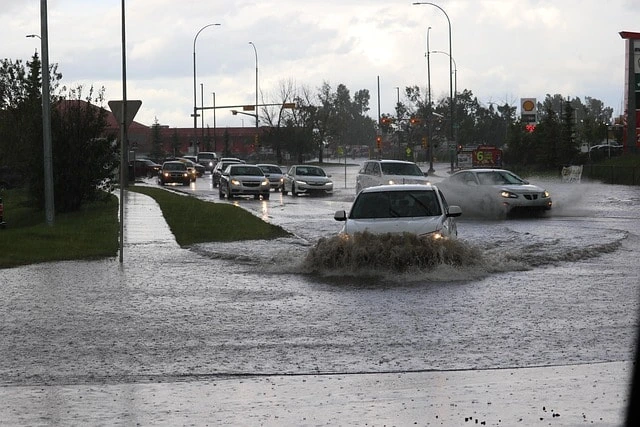
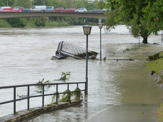
Flooding isn’t new to Auckland, but the last few years have shown us just how vulnerable parts of our city can be—especially after the Auckland Anniversary floods in early 2023 and further weather events that followed. Heavy rainfall during these events led to significant flood water impacting many properties. As real estate agents working across West Auckland, we’re seeing firsthand how flooding affects property values, insurance, and buyer behaviour.
Here’s what you need to know whether you’re buying, selling, or already own a home in an at-risk area. Understanding how flood water can affect homes is crucial for making informed decisions.
There are three main reasons:
Climate change is increasing the intensity and frequency of heavy rain.
Aging infrastructure is struggling to cope with urban growth.
More infill housing has reduced permeable land, making it harder for stormwater to soak into the ground.
Even areas once considered safe are now seeing surface flooding or overloaded drains during downpours.
Flood hazards are a significant concern for property owners and developers in West Auckland, where frequent flooding can impact both new developments and existing buildings. The region’s low-lying land and proximity to the coast make it especially vulnerable to flood events, so understanding your property’s flood risk is essential.
Flood hazard maps and flood models, provided by the regional council, are key resources for identifying flood hazard areas and understanding the potential impact of mapped flooding. These tools offer detailed flood hazard information, showing where flood events are most likely to occur and helping property owners make informed decisions about flood management and emergency management planning.
If you’re considering buying, selling, or developing in West Auckland, it’s important to seek professional advice when interpreting flood hazard maps and modelling data. Experts can help you understand the specific flood hazards affecting your property and recommend steps to reduce your risk—such as upgrading drainage systems or installing more effective stormwater systems.
Regularly updated hazard maps and flood hazard information are crucial for staying ahead of changing flood risks. By staying informed and proactive, property owners can better protect their homes and investments from the impacts of flooding.
Accurate flood prediction and mapping are at the heart of effective flood hazard modelling in West Auckland. Using advanced computer models, experts can simulate flood events and predict the likely flood extent, helping to identify flood hazard areas and flood prone areas before disaster strikes.
Key data sources for flood mapping include land contours, sea level rise projections, and annual exceedance probability (AEP) figures, which estimate how often a flood event might occur in any given year. This information is used to determine flood levels, map overland flow paths, and highlight areas at risk from river flooding or stormwater overflow.
Modern flood mapping also relies on light detection and ranging (LIDAR) technology, which provides highly accurate ground level data. This allows for more precise identification of flood hazard areas and helps ensure that stormwater systems and drainage systems are designed to handle even extreme rainfall events.
Property owners and developers can access updated, peer-reviewed flood mapping data and flood hazard information through the regional council’s website or by consulting a qualified professional. Using the latest, most reliable data is essential for making informed decisions about land use, building consents, and flood management strategies—helping to safeguard your property against future flooding risks.
1. Buyer Hesitation:
Many buyers are now reviewing council flood maps and LIM reports closely. If flooding or ponding shows up even if it’s minor it raises red flags.
2. Insurance Barriers:
Some insurers have increased premiums or added exclusions for flood-prone properties. In a few cases, they’ve declined coverage altogether.
3. Property Values:
Homes in known flood zones may attract lower offers, especially if buyers factor in future mitigation costs or resale risks.
4. More Questions at Open Homes:
We’re seeing more detailed questions about stormwater drains, gutters, landscaping, and historical flooding even in properties with no known issues.
If your home is in a flood-prone area or shows on the flood plain maps:
Be upfront. Buyers appreciate honesty, and hiding it will likely backfire during due diligence.
Show maintenance records. Demonstrate that drains, gutters, and landscaping have been well cared for.
Provide context. If there’s a historical issue from 2016 or 2018, explain whether it was due to construction oversight or lack of council follow-through.
Note current works. If drainage improvements or council works are underway, make that clear. For example: “Issue identified in 2018, currently being resolved and scheduled for completion before settlement.”
It’s important to interpret LIM reports correctly. Not all “flood hazards” mean the home has flooded. LIMs often include:
Overland flow paths (where stormwater naturally travels)
Ponding areas (low spots where water may collect)
Council records from subdivision time (e.g., 2016–2018)
We recommend reading these in context, and we’re happy to walk buyers or sellers through them alongside their solicitors and builders.
Yes, but you need the right strategy. Here’s what we’ve seen work:
Clear, open communication
Highlighting positives like elevation, drainage improvements, or no history of water ingress
Providing quotes or plans for future-proofing
Timing your campaign around good weather and showcasing the home’s best features
We’ve successfully sold multiple homes in areas like Glen Eden, New Lynn, and Westgate where council flood overlays existed—but buyers were reassured through transparency and data.
Auckland Council is reviewing and updating flood maps post-2023 events.
Insurers are using new flood risk models (some driven by reinsurers).
Building consents are now stricter for flood-prone land, requiring elevated floor levels or engineered drainage.
If you’re unsure how flooding may affect your property or your next purchase, speak to us. We can help interpret the LIM, talk through buyer sentiment, and show you recent case studies of similar homes we’ve sold.
Flooding doesn’t mean you can’t sell or buy. It just means being smart, prepared, and well-informed.
For further information on floodplain zones or flood hazard maps, you can contact your regional council, consult technical reports, or seek advice from professional advisors.
Need help understanding how your home might be affected?📍 Contact the Area Specialist team at Ray White New Lynn 📞 02 2600 2600 | 📧 [email protected]